
Make a donation
Gear up for your next adventure:
As an Amazon Associate, this site earns from qualifying purchases at no extra cost to you.
Saint-Anaclet-de-Lessard topographic map
Click on the map to display elevation.
Make a donation
Gear up for your next adventure:
As an Amazon Associate, this site earns from qualifying purchases at no extra cost to you.
About this map
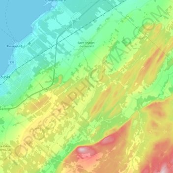
Name: Saint-Anaclet-de-Lessard topographic map, elevation, terrain.
Average elevation: 128 m
Minimum elevation: 0 m
Maximum elevation: 385 m
Make a donation
Gear up for your next adventure:
As an Amazon Associate, this site earns from qualifying purchases at no extra cost to you.
Other topographic maps
Click on a map to view its topography, its elevation and its terrain.
Point de la plus belle vue
Canada > Québec > Rimouski-Neigette > Saint-Fabien
Average elevation: 115 m
Make a donation
Gear up for your next adventure:
As an Amazon Associate, this site earns from qualifying purchases at no extra cost to you.
Make a donation
Gear up for your next adventure:
As an Amazon Associate, this site earns from qualifying purchases at no extra cost to you.
Pic Champlain
Canada > Québec > Rimouski-Neigette > Saint-Fabien
L'altitude plutôt modeste du pic Champlain (346 m) est compensée par sa proximité de l'estuaire du fleuve Saint-Laurent.
Average elevation: 117 m
Make a donation
Gear up for your next adventure:
As an Amazon Associate, this site earns from qualifying purchases at no extra cost to you.
Esprit-Saint
Canada > Québec > Rimouski-Neigette > Esprit-Saint > Esprit-Saint
Average elevation: 295 m