
Make a donation
Gear up for your next adventure:
As an Amazon Associate, this site earns from qualifying purchases at no extra cost to you.
Saint-Fabien-sur-Mer topographic map
Click on the map to display elevation.
Make a donation
Gear up for your next adventure:
As an Amazon Associate, this site earns from qualifying purchases at no extra cost to you.
About this map
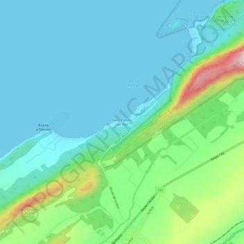
Name: Saint-Fabien-sur-Mer topographic map, elevation, terrain.
Average elevation: 71 m
Minimum elevation: 0 m
Maximum elevation: 326 m
Make a donation
Gear up for your next adventure:
As an Amazon Associate, this site earns from qualifying purchases at no extra cost to you.
Other topographic maps
Click on a map to view its topography, its elevation and its terrain.
Parc national du Bic
Canada > Québec > Rimouski-Neigette > Saint-Fabien
Le parc national du Bic est un parc national du Québec (Canada) situé à 15 km à l'ouest de Rimouski. Le parc, qui a une superficie de 33,2 km2, comprend une section découpée de la côte de l'estuaire du Saint-Laurent comptant une douzaine de baies et un relief accidenté culminant au pic Champlain à 346…
Average elevation: 65 m