Geolocate

Russell Springs topographic map

Click on the map to display elevation.

About this map

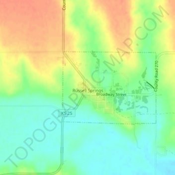
Name: Russell Springs topographic map, elevation, terrain.

Location: Russell Springs, Logan County, Kansas, United States (38.90702 -101.18519 38.91820 -101.16665)

Average elevation: 894 m

Minimum elevation: 874 m

Maximum elevation: 916 m

Other topographic maps

Click on a map to view its topography, its elevation and its terrain.

Twin Butte

United States > Kansas > Logan County

Average elevation: 996 m

Gear up for your next adventure:

🦶Anti-Blister Balm - Prevents friction and hotspots during long ascents
🚲Handlebar Phone Mount - View topographic-map.com live while cycling
🧴Waterproofing Spray - Restore the DWR coating on jackets and tents
🥾Light Hiking Boots - Lightweight and comfortable boots for day hikes
🧼Biodegradable Camp Soap - Environmentally friendly cleaning for gear and body

As an Amazon Associate, this site earns from qualifying purchases at no extra cost to you.