Geolocate

Norridgewock topographic map

Click on the map to display elevation.

About this map
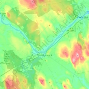
Name: Norridgewock topographic map, elevation, terrain.

Location: Norridgewock, Somerset County, Maine, 04957, United States (44.66971 -69.90360 44.78505 -69.73194)

Average elevation: 97 m

Minimum elevation: 29 m

Maximum elevation: 231 m

Other topographic maps

Click on a map to view its topography, its elevation and its terrain.
Pratt Hill

United States > Maine > Somerset County > Skowhegan

Average elevation: 113 m

Bigelow Hill

United States > Maine > Somerset County > Skowhegan

Average elevation: 158 m

Mackamp

United States > Maine > Somerset County

Average elevation: 395 m

Gray Island

United States > Maine > Somerset County > Solon

Average elevation: 105 m

Norris Brook

United States > Maine > Somerset County

Average elevation: 420 m

Gear up for your next adventure:

🧼Biodegradable Camp Soap - Environmentally friendly cleaning for gear and body
🧤Thermal Hiking Gloves - Grip-enhanced gloves for cold-weather altitude trekking
🔥Camping Stove - Portable stoves to cook outdoors with ease
🗺️Topographic Maps - Detailed maps to explore trails, mountains, and wilderness areas
🛶Waterproof Dry Bags - Keep electronics and clothes dry during river crossings

As an Amazon Associate, this site earns from qualifying purchases at no extra cost to you.