Geolocate

Mount Carmel topographic map

Click on the map to display elevation.

About this map
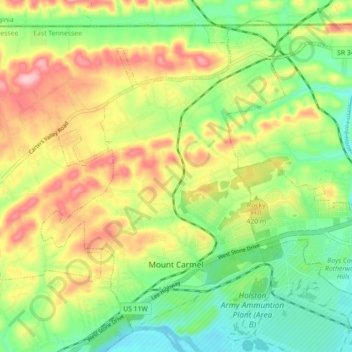
Name: Mount Carmel topographic map, elevation, terrain.

Location: Mount Carmel, Hawkins County, East Tennessee, Tennessee, 37645, United States (36.53228 -82.69508 36.59407 -82.60617)

Average elevation: 423 m

Minimum elevation: 347 m

Maximum elevation: 525 m

Other topographic maps

Click on a map to view its topography, its elevation and its terrain.
Eidson

United States > Tennessee > Hawkins County

Average elevation: 526 m

Stacy

United States > Tennessee > Hawkins County

Average elevation: 453 m

Shiloh

United States > Tennessee > Hawkins County

Average elevation: 539 m

Mooresburg

United States > Tennessee > Hawkins County

Average elevation: 372 m

Persia

United States > Tennessee > Hawkins County

Average elevation: 363 m

Eidson

United States > Tennessee > Hawkins County

Average elevation: 526 m

Altonville

United States > Tennessee > Hawkins County

Average elevation: 402 m

Gear up for your next adventure:

🎒Fully Waterproof Backpack - Total protection for photography gear and electronics
👖Convertible Hiking Pants - Zip-off legs to adapt to changing weather conditions
🥾Light Hiking Boots - Lightweight and comfortable boots for day hikes
🥾Trekking Boots - Durable boots for long-distance trekking
⛺Tent Footprint - Protect tent floor and increase durability

As an Amazon Associate, this site earns from qualifying purchases at no extra cost to you.