Geolocate

Church Hill topographic map

Click on the map to display elevation.

About this map

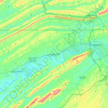
Name: Church Hill topographic map, elevation, terrain.

Location: Church Hill, Hawkins County, Tennessee, 37642, United States (36.36232 -82.87349 36.68232 -82.55349)

Average elevation: 463 m

Minimum elevation: 327 m

Maximum elevation: 907 m

Gear up for your next adventure:

👖Convertible Hiking Pants - Zip-off legs to adapt to changing weather conditions
🎒Backpack Rain Cover - External shield to keep your entire pack dry
🥾Light Trekking Boots - Supportive boots for multi-day treks
Family Camping Tent - Spacious tent suitable for family camping trips
🥾Waterproof Hiking Boots - Essential footwear for rugged terrain and wet Canadian trails

As an Amazon Associate, this site earns from qualifying purchases at no extra cost to you.