Geolocate

Authon topographic map

Click on the map to display elevation.

About this map

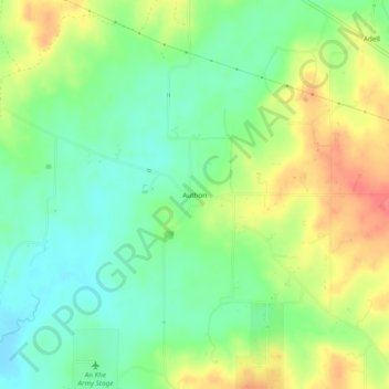
Name: Authon topographic map, elevation, terrain.

Location: Authon, Parker County, Texas, United States (32.84846 -97.96393 32.88846 -97.92393)

Average elevation: 318 m

Minimum elevation: 291 m

Maximum elevation: 356 m

Other topographic maps

Click on a map to view its topography, its elevation and its terrain.

Weatherford

United States > Texas > Parker County

Average elevation: 326 m

Reno

United States > Texas > Parker County

Average elevation: 233 m

Snake Forest

United States > Texas > Parker County

Average elevation: 312 m

Aledo

United States > Texas > Parker County

Average elevation: 271 m

Springtown

United States > Texas > Parker County

Average elevation: 273 m

Millsap

United States > Texas > Parker County

Average elevation: 257 m

Aledo

United States > Texas > Parker County

Average elevation: 271 m

Weatherford

United States > Texas > Parker County

Average elevation: 326 m

Gear up for your next adventure:

🔋Lithium AA Batteries - Long-lasting power that performs in extreme cold
🛁Quick-Dry Microfiber Towel - Space-saving towel that dries rapidly on the move
🥾Mountain Trail Shoes - High-traction shoes for mountain trails
🧭GPS Outdoor Watch - Smart watch for navigation and fitness tracking in nature
🎒Hiking Backpack - Lightweight and ergonomic backpacks for day hikes or multi-day treks

As an Amazon Associate, this site earns from qualifying purchases at no extra cost to you.