Geolocate

Visby topographic map

Click on the map to display elevation.

About this map

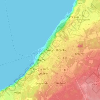
Name: Visby topographic map, elevation, terrain.

Location: Visby, Gotland Municipality, Gotland County, 621 45, Sweden (57.47794 18.13798 57.79794 18.45798)

Average elevation: 23 m

Minimum elevation: 0 m

Maximum elevation: 83 m

Other topographic maps

Click on a map to view its topography, its elevation and its terrain.

Gotland Municipality

Sweden > Gotland County

Average elevation: 2 m

Fårö

Sweden > Gotland County

Average elevation: 5 m

Gear up for your next adventure:

💧Hydration Bladder - Hands-free hydration solution for long treks
🧼Travel Hand Sanitizer - Keep hands clean when water is scarce
🧥Insulated Jacket - Keep warm in cold outdoor conditions
🕯️Camping Lantern - Illuminates your entire campsite with high-efficiency LEDs
🥾Trail Hiking Socks - Comfortable socks to prevent blisters and fatigue

As an Amazon Associate, this site earns from qualifying purchases at no extra cost to you.