Geolocate

Callington topographic map

Click on the map to display elevation.

About this map

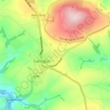
Name: Callington topographic map, elevation, terrain.

Location: Callington, Cornwall, England, United Kingdom (50.48529 -4.34464 50.52436 -4.27807)

Average elevation: 166 m

Minimum elevation: 36 m

Maximum elevation: 331 m

Other topographic maps

Click on a map to view its topography, its elevation and its terrain.

Maders

United Kingdom > England > Cornwall > Callington

Average elevation: 145 m

Kit Hill

United Kingdom > England > Cornwall > Callington

Average elevation: 205 m

Gear up for your next adventure:

🥾Waterproof Hiking Boots - Essential footwear for rugged terrain and wet Canadian trails
🧢Outdoor Cap - Protective cap for sun and rain during hikes
🪑Insulated Seat Pad - Protect your seat from cold rocks and wet logs
💡Compact LED Flashlight - Powerful and portable flashlight for outdoor use
🥽Outdoor Goggles - Protective eyewear for outdoor activities

As an Amazon Associate, this site earns from qualifying purchases at no extra cost to you.