Geolocate

Bellaire topographic map

Click on the map to display elevation.

About this map

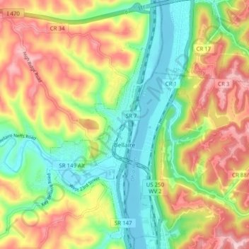
Name: Bellaire topographic map, elevation, terrain.

Location: Bellaire, Belmont County, Ohio, United States (39.99146 -80.76544 40.05049 -80.73046)

Average elevation: 283 m

Minimum elevation: 189 m

Maximum elevation: 404 m

Other topographic maps

Click on a map to view its topography, its elevation and its terrain.

Steinersville

United States > Ohio > Belmont County

Average elevation: 267 m

Warnock

United States > Ohio > Belmont County

Average elevation: 337 m

Gear up for your next adventure:

🪑Ultralight Camping Stool - Compact seating for rest stops during long hikes
🧦Hiking Socks - Moisture-wicking and comfortable socks for long hikes
🧊Insulated Water Bottle - Keeps drinks cold in summer and prevents freezing in winter
🔭Compact Monocular - One-handed bird watching and trail spotting
🧭GPS Handheld Device - Reliable GPS navigation for outdoor adventures

As an Amazon Associate, this site earns from qualifying purchases at no extra cost to you.