Geolocate

Steinersville topographic map

Click on the map to display elevation.

About this map

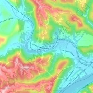
Name: Steinersville topographic map, elevation, terrain.

Location: Steinersville, Belmont County, Ohio, 43942, United States (39.84896 -80.85120 39.88896 -80.81120)

Average elevation: 267 m

Minimum elevation: 185 m

Maximum elevation: 395 m

Other topographic maps

Click on a map to view its topography, its elevation and its terrain.

Bellaire

United States > Ohio > Belmont County

Average elevation: 283 m

St. Clairsville

United States > Ohio > Belmont County

Average elevation: 355 m

Morristown

United States > Ohio > Belmont County

Average elevation: 374 m

St. Clairsville

United States > Ohio > Belmont County

Average elevation: 355 m

Gear up for your next adventure:

🔪Outdoor Multitool - Versatile tool for repairs and food prep in the wild
🧤Rechargeable Heated Gloves - Extreme warmth for Canadian winter expeditions
🗺️Topographic Maps - Detailed maps to explore trails, mountains, and wilderness areas
🔥Camping Stove - Portable stoves to cook outdoors with ease
Family Camping Tent - Spacious tent suitable for family camping trips

As an Amazon Associate, this site earns from qualifying purchases at no extra cost to you.