Geolocate

Four Marks topographic map

Click on the map to display elevation.

About this map

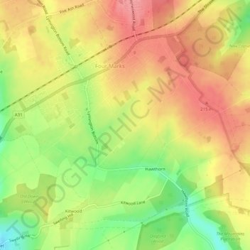
Name: Four Marks topographic map, elevation, terrain.

Location: Four Marks, East Hampshire, Hampshire, England, United Kingdom (51.09057 -1.06530 51.11666 -1.01549)

Average elevation: 185 m

Minimum elevation: 133 m

Maximum elevation: 223 m

Gear up for your next adventure:

👖Convertible Hiking Pants - Zip-off legs to adapt to changing weather conditions
🥘Camping Cookware Set - Compact nesting pots and pans for trail cooking
🥾Light Trekking Boots - Supportive boots for multi-day treks
🪑Ultralight Camping Stool - Compact seating for rest stops during long hikes
🧭GPS Outdoor Watch - Smart watch for navigation and fitness tracking in nature

As an Amazon Associate, this site earns from qualifying purchases at no extra cost to you.