
Make a donation
Gear up for your next adventure:
As an Amazon Associate, this site earns from qualifying purchases at no extra cost to you.
Goldenstedt topographic map
Click on the map to display elevation.
Make a donation
Gear up for your next adventure:
As an Amazon Associate, this site earns from qualifying purchases at no extra cost to you.
Goldenstedt
In Ellenstedt existiert ein Windpark. Dort stürzte im Jahr 2002 eine Windkraftanlage mit 70 Metern Nabenhöhe um.
Make a donation
Gear up for your next adventure:
As an Amazon Associate, this site earns from qualifying purchases at no extra cost to you.
About this map
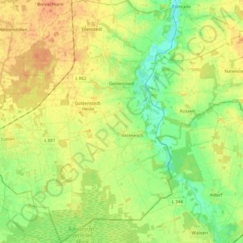
Name: Goldenstedt topographic map, elevation, terrain.
Location: Goldenstedt, Landkreis Vechta, Niedersachsen, 49424, Deutschland (52.71223 8.30906 52.82619 8.47367)
Average elevation: 39 m
Minimum elevation: 21 m
Maximum elevation: 57 m
Make a donation
Gear up for your next adventure:
As an Amazon Associate, this site earns from qualifying purchases at no extra cost to you.
Other topographic maps
Click on a map to view its topography, its elevation and its terrain.
Make a donation
Gear up for your next adventure:
As an Amazon Associate, this site earns from qualifying purchases at no extra cost to you.
Make a donation
Gear up for your next adventure:
As an Amazon Associate, this site earns from qualifying purchases at no extra cost to you.
Severinghausen
Deutschland > Niedersachsen > Landkreis Vechta > Neuenkirchen-Vörden
Average elevation: 59 m
Haverbeck
Deutschland > Niedersachsen > Landkreis Vechta > Damme > Langenteilen
Average elevation: 51 m
Rüschendorf
Deutschland > Niedersachsen > Landkreis Vechta > Damme > Rüschendorf
Average elevation: 50 m
Make a donation
Gear up for your next adventure:
As an Amazon Associate, this site earns from qualifying purchases at no extra cost to you.
Langenteilen
Deutschland > Niedersachsen > Landkreis Vechta > Damme > Langenteilen
Average elevation: 47 m
Nellinghof
Deutschland > Niedersachsen > Landkreis Vechta > Neuenkirchen-Vörden
Average elevation: 51 m
Make a donation
Gear up for your next adventure:
As an Amazon Associate, this site earns from qualifying purchases at no extra cost to you.