
Stoke topographic map
Click on the map to display elevation.
About this map
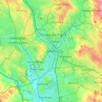
Name: Stoke topographic map, elevation, terrain.
Location: Stoke, Stoke-on-Trent, England, ST4 4AA, United Kingdom (52.96336 -2.22469 53.04336 -2.14469)
Average elevation: 142 m
Minimum elevation: 96 m
Maximum elevation: 232 m
Other topographic maps
Click on a map to view its topography, its elevation and its terrain.
Biddulph Valley Line
United Kingdom > England > Stoke-on-Trent > Hanley > Eaton Park
Average elevation: 138 m