
Old Jefferson topographic map
Click on the map to display elevation.
About this map
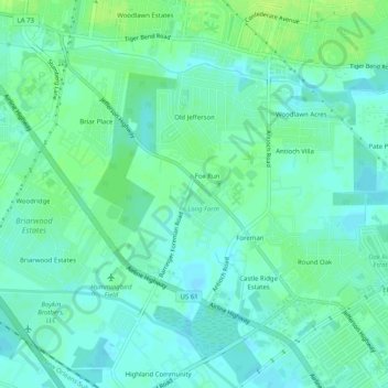
Name: Old Jefferson topographic map, elevation, terrain.
Average elevation: 9 m
Minimum elevation: 3 m
Maximum elevation: 16 m
Other topographic maps
Click on a map to view its topography, its elevation and its terrain.
Bell Fontaine
United States > Louisiana > East Baton Rouge Parish > Baton Rouge
Average elevation: 16 m
Goodwood Homesites
United States > Louisiana > East Baton Rouge Parish > Baton Rouge
Average elevation: 18 m
Florida Plaza
United States > Louisiana > East Baton Rouge Parish > Baton Rouge
Average elevation: 19 m
Mayfair Park North
United States > Louisiana > East Baton Rouge Parish > Baton Rouge
Average elevation: 12 m
Sherwood Forest
United States > Louisiana > East Baton Rouge Parish > Baton Rouge
Average elevation: 16 m
Steele Place
United States > Louisiana > East Baton Rouge Parish > Baton Rouge > Steele Place
Average elevation: 17 m
Highland Farms
United States > Louisiana > East Baton Rouge Parish > Baton Rouge > Highland Farms
Average elevation: 19 m
Tristian Village
United States > Louisiana > East Baton Rouge Parish > Baker > Tristian Village
Average elevation: 25 m
Glen Oaks
United States > Louisiana > East Baton Rouge Parish > Baton Rouge > Glen Oaks
Average elevation: 21 m
Parkview Oaks South
United States > Louisiana > East Baton Rouge Parish > Baton Rouge
Average elevation: 13 m