
Bahía Honda topographic map
Interactive map
Click on the map to display elevation.
About this map
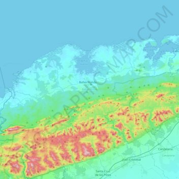
Name: Bahía Honda topographic map, elevation, terrain.
Location: Bahía Honda, Artemisa, 14400, Cuba (22.75957 -83.40051 23.01149 -82.92937)
Average elevation: 103 m
Minimum elevation: 0 m
Maximum elevation: 686 m
Other topographic maps
Click on a map to view its topography, its elevation and its terrain.
San Juan
Cuba > Artemisa > Candelaria
San Juan, Candelaria, Artemisa, 24700, Cuba
Average elevation: 170 m