
Candelaria topographic map
Interactive map
Click on the map to display elevation.
About this map
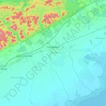
Name: Candelaria topographic map, elevation, terrain.
Location: Candelaria, Artemisa, Cuba (22.57146 -83.11703 22.87527 -82.82110)
Average elevation: 80 m
Minimum elevation: 0 m
Maximum elevation: 593 m
Other topographic maps
Click on a map to view its topography, its elevation and its terrain.
San Juan
Cuba > Artemisa > Candelaria
San Juan, Candelaria, Artemisa, 24700, Cuba
Average elevation: 170 m