
Pontotoc County topographic map
Click on the map to display elevation.
About this map
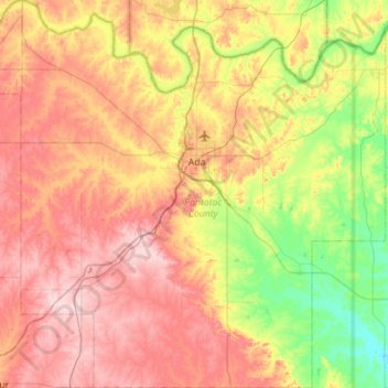
Name: Pontotoc County topographic map, elevation, terrain.
Location: Pontotoc County, Oklahoma, United States (34.50548 -96.93251 34.96582 -96.40611)
Average elevation: 292 m
Minimum elevation: 186 m
Maximum elevation: 407 m
Other topographic maps
Click on a map to view its topography, its elevation and its terrain.
Southwest Oklahoma City Sludge Lagoon Dam
United States > Oklahoma > Cleveland County > Oklahoma City
Average elevation: 348 m
Lake Thunderbird Dam
United States > Oklahoma > Cleveland County > Norman > Little Axe
Average elevation: 318 m