Geolocate

Schaumburg topographic map

Click on the map to display elevation.

Schaumburg

According to the 2021 census gazetteer files, Schaumburg has a total area of 19.47 square miles (50.43 km2), of which 19.35 square miles (50.12 km2) (or 99.39%) is land and 0.12 square miles (0.31 km2) (or 0.61%) is water. Its elevation varies between 750 and 850 feet above sea level, with a high point of 850 feet at the intersection of Schaumburg Road and Webster Lane. Schaumburg serves as the headwaters of the West Branch Dupage River, which drains the central and western portions of the village, flowing to the southwest. The West Branch of the Salt Creek drains the eastern portion of the village, flowing eastward into Busse Lake.

Wikipedia (CC-BY-SA 3.0)

About this map

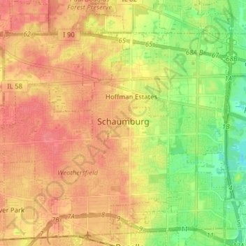
Name: Schaumburg topographic map, elevation, terrain.

Location: Schaumburg, Schaumburg Township, Cook County, Illinois, United States (41.98686 -88.15436 42.07811 -88.02802)

Average elevation: 237 m

Minimum elevation: 204 m

Maximum elevation: 261 m

Other topographic maps

Click on a map to view its topography, its elevation and its terrain.

Lemont

United States > Illinois > Cook County

Average elevation: 208 m

Riis Park

United States > Illinois > Cook County > Chicago

Average elevation: 194 m

Lemont

United States > Illinois > Cook County

Average elevation: 208 m

Chicagoland

United States > Illinois > Cook County > Chicago

Average elevation: 208 m

Stanton Park

United States > Illinois > Cook County > Chicago

Average elevation: 183 m

Willow Park

United States > Illinois > Cook County > Northfield

Average elevation: 195 m

Garfield Park

United States > Illinois > Cook County > Chicago

Average elevation: 184 m

Riis Park

United States > Illinois > Cook County > Chicago

Average elevation: 194 m

Brentwood

United States > Illinois > Cook County

Average elevation: 237 m

Palatine

United States > Illinois > Cook County

Average elevation: 228 m

Palatine

United States > Illinois > Cook County

Average elevation: 228 m

Bessemer Park

United States > Illinois > Cook County > Chicago

Average elevation: 180 m

Pulaski Park

United States > Illinois > Cook County > Chicago

Average elevation: 182 m

Maple Lake

United States > Illinois > Cook County

Average elevation: 203 m

Hamilton Park

United States > Illinois > Cook County > Chicago

Average elevation: 183 m

Duxbury Park

United States > Illinois > Cook County > Schaumburg

Average elevation: 249 m

Columbia Basin

United States > Illinois > Cook County > Chicago

Average elevation: 180 m

Stockham Park

United States > Illinois > Cook County > Evanston

Average elevation: 181 m

Gear up for your next adventure:

🚲Handlebar Phone Mount - View topographic-map.com live while cycling
🦟Insect Repellent - Keep mosquitoes and black flies away in wooded areas
🥾Mountain Hiking Boots - High-traction boots for rocky terrain
💧Hydration Bladder - Hands-free hydration solution for long treks
🥾All-Terrain Hiking Boots - Versatile boots for varied hiking conditions

As an Amazon Associate, this site earns from qualifying purchases at no extra cost to you.