
Falmouth topographic map
Interactive map
Click on the map to display elevation.
About this map
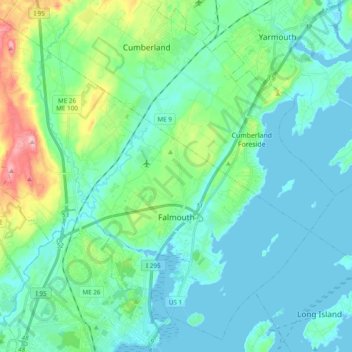
Name: Falmouth topographic map, elevation, terrain.
Location: Falmouth, Cumberland County, Maine, 04105, United States (43.68113 -70.36123 43.81031 -70.16904)
Average elevation: 29 m
Minimum elevation: -2 m
Maximum elevation: 149 m
Other topographic maps
Click on a map to view its topography, its elevation and its terrain.
South Portland
United States > Maine > Cumberland County
South Portland, Cumberland County, Maine, 04106, United States
Average elevation: 9 m
Sebascodegan Island
United States > Maine > Cumberland County > Harpswell
Sebascodegan Island, Harpswell, Cumberland County, Maine, 04079, United States
Average elevation: 8 m
Little Sebago Lake
United States > Maine > Cumberland County > Gray
Little Sebago Lake, Gray, Cumberland County, Maine, 04039, United States
Average elevation: 108 m
Pownal
United States > Maine > Cumberland County
Pownal, Cumberland County, Maine, 04069, United States
Average elevation: 54 m
Cumberland
United States > Maine > Cumberland County
Cumberland, Cumberland County, Maine, United States
Average elevation: 51 m
Harpswell
United States > Maine > Cumberland County
Harpswell, Cumberland County, Maine, 04079, United States
Average elevation: 5 m
Brunswick
United States > Maine > Cumberland County
Brunswick, Cumberland County, Maine, 04011, United States
Average elevation: 24 m
Crescent Beach
United States > Maine > Cumberland County > Cape Elizabeth
Crescent Beach, Cape Elizabeth, Cumberland County, Maine, 04107, United States
Average elevation: 6 m
Birch Island
United States > Maine > Cumberland County > Harpswell > Birch Island
Birch Island, Harpswell, Cumberland County, Maine, 04079, United States
Average elevation: 3 m