Geolocate

Bingham topographic map

Click on the map to display elevation.

About this map
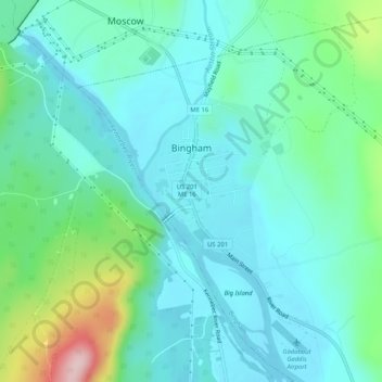
Name: Bingham topographic map, elevation, terrain.

Location: Bingham, Somerset County, Maine, United States (44.97757 -69.89808 45.08286 -69.75037)

Average elevation: 205 m

Minimum elevation: 89 m

Maximum elevation: 511 m

Other topographic maps

Click on a map to view its topography, its elevation and its terrain.
Pratt Hill

United States > Maine > Somerset County > Skowhegan

Average elevation: 113 m

Bigelow Hill

United States > Maine > Somerset County > Skowhegan

Average elevation: 158 m

Mackamp

United States > Maine > Somerset County

Average elevation: 395 m

Gray Island

United States > Maine > Somerset County > Solon

Average elevation: 105 m

Norris Brook

United States > Maine > Somerset County

Average elevation: 420 m

Gear up for your next adventure:

🧦Thermal Socks - Warm socks for winter hiking or camping
🔪Outdoor Multitool - Versatile tool for repairs and food prep in the wild
🔦LED Flashlight - Powerful and long-lasting flashlight for camping and emergencies
⛺Lightweight Backpacking Tent - Compact tent for efficient hiking trips
🔦LED Headtorch - Bright and durable light for night activities

As an Amazon Associate, this site earns from qualifying purchases at no extra cost to you.