
Make a donation
Gear up for your next adventure:
As an Amazon Associate, this site earns from qualifying purchases at no extra cost to you.
Camp Wilkerson topographic map
Click on the map to display elevation.
Make a donation
Gear up for your next adventure:
As an Amazon Associate, this site earns from qualifying purchases at no extra cost to you.
About this map
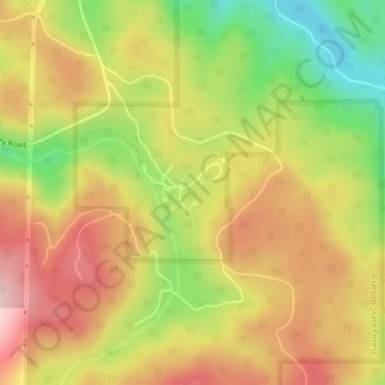
Name: Camp Wilkerson topographic map, elevation, terrain.
Location: Camp Wilkerson, Columbia County, Oregon, United States (45.92534 -123.05072 45.92544 -123.05062)
Average elevation: 391 m
Minimum elevation: 254 m
Maximum elevation: 504 m
Make a donation
Gear up for your next adventure:
As an Amazon Associate, this site earns from qualifying purchases at no extra cost to you.
Other topographic maps
Click on a map to view its topography, its elevation and its terrain.
Vernonia
United States > Oregon > Columbia County
The city has been severely impacted by floods on multiple occasions. The rains that caused the Willamette Valley Flood of 1996 flooded Vernonia as well; some homes in the floodplain were elevated, and some flooring materials were replaced, mitigating some damage from later flooding. In 2007, heavy storms that…
Average elevation: 218 m
Make a donation
Gear up for your next adventure:
As an Amazon Associate, this site earns from qualifying purchases at no extra cost to you.
Vernonia
United States > Oregon > Columbia County
The city has been severely impacted by floods on multiple occasions. The rains that caused the Willamette Valley Flood of 1996 flooded Vernonia as well; some homes in the floodplain were elevated, and some flooring materials were replaced, mitigating some damage from later flooding. In 2007, heavy storms that…
Average elevation: 218 m
Make a donation
Gear up for your next adventure:
As an Amazon Associate, this site earns from qualifying purchases at no extra cost to you.
Make a donation
Gear up for your next adventure:
As an Amazon Associate, this site earns from qualifying purchases at no extra cost to you.