
Make a donation
Gear up for your next adventure:
As an Amazon Associate, this site earns from qualifying purchases at no extra cost to you.
Swords topographic map
Click on the map to display elevation.
Make a donation
Gear up for your next adventure:
As an Amazon Associate, this site earns from qualifying purchases at no extra cost to you.
Swords
At the northern end of the street stands Swords Castle, 200m northeast of the ecclesiastical site, which was built in the early 13th century. A short distance north of the castle is the elevation known as Spittal Hill, where a hospital once stood.
Make a donation
Gear up for your next adventure:
As an Amazon Associate, this site earns from qualifying purchases at no extra cost to you.
About this map
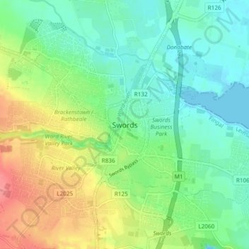
Name: Swords topographic map, elevation, terrain.
Location: Swords, Fingal, County Dublin, Leinster, Ireland (53.44097 -6.26919 53.47797 -6.19511)
Average elevation: 25 m
Minimum elevation: -5 m
Maximum elevation: 70 m
Make a donation
Gear up for your next adventure:
As an Amazon Associate, this site earns from qualifying purchases at no extra cost to you.
Other topographic maps
Click on a map to view its topography, its elevation and its terrain.
Make a donation
Gear up for your next adventure:
As an Amazon Associate, this site earns from qualifying purchases at no extra cost to you.