Geolocate

Hinwil topographic map

Click on the map to display elevation.

About this map
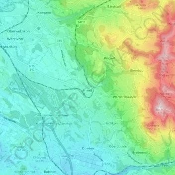
Name: Hinwil topographic map, elevation, terrain.

Location: Hinwil, Bezirk Hinwil, Zurich, Switzerland (47.27874 8.80378 47.32667 8.90980)

Average elevation: 652 m

Minimum elevation: 490 m

Maximum elevation: 1,112 m

Other topographic maps

Click on a map to view its topography, its elevation and its terrain.

Nübruch

Switzerland > Zurich > Bezirk Hinwil > Ringwil

Average elevation: 763 m

Schnebelhorn

Switzerland > Zurich > Bezirk Hinwil > Fischenthal

Average elevation: 1,025 m

Wolfhausen

Switzerland > Zurich > Bezirk Hinwil

Average elevation: 497 m

Wacht

Switzerland > Zurich > Bezirk Hinwil > Rüti (ZH)

Average elevation: 511 m

Steg

Switzerland > Zurich > Bezirk Hinwil

Average elevation: 836 m

Gear up for your next adventure:

🔦UV Flashlight - Detect minerals or specific insects in the dark
🛶Kayak Accessories - Essential gear for safe and fun kayaking adventures
👟Leg Gaiters - Keep debris, mud, and snow out of your boots
🧴First Aid Kit - Essential first aid supplies for outdoor emergencies
⛺Family Camping Tent - Spacious tent suitable for family camping trips

As an Amazon Associate, this site earns from qualifying purchases at no extra cost to you.