
St Albans topographic map
Click on the map to display elevation.
St Albans
The borough consisted of the ancient parish of St Albans (also known as the Abbey parish) and parts of the parishes of St Michael and St Peter. The borough was reformed by the Municipal Corporations Act 1835 to become a municipal borough, and the boundary was adjusted to additionally include part of the parish of St Stephen. On 28 August 1877 the borough gained city status, following the elevation of St Albans Abbey to become a cathedral. The boundary was also adjusted in 1877 to include part of the parish of Sandridge.
About this map
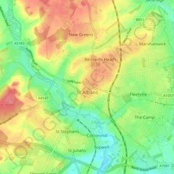
Name: St Albans topographic map, elevation, terrain.
Location: St Albans, Hertfordshire, England, United Kingdom (51.72913 -0.37529 51.78007 -0.29102)
Average elevation: 103 m
Minimum elevation: 69 m
Maximum elevation: 141 m
Other topographic maps
Click on a map to view its topography, its elevation and its terrain.
Kitcher's Pond
United Kingdom > England > Hertfordshire > East Hertfordshire > Albury
Average elevation: 106 m
Tyttenhanger
United Kingdom > England > Hertfordshire > St Albans > Colney Heath
Average elevation: 83 m
Bushey Heath
United Kingdom > England > Hertfordshire > Hertsmere > Bushey Heath
Average elevation: 110 m
Stanstead Abbotts
United Kingdom > England > Hertfordshire > East Hertfordshire
Average elevation: 48 m