Geolocate

Thurnham topographic map

Click on the map to display elevation.

About this map

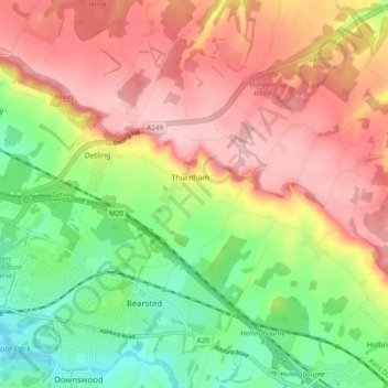
Name: Thurnham topographic map, elevation, terrain.

Location: Thurnham, Maidstone, Kent, England, United Kingdom (51.25900 0.56092 51.31845 0.63019)

Average elevation: 114 m

Minimum elevation: 20 m

Maximum elevation: 203 m

Gear up for your next adventure:

🪑Ultralight Camping Stool - Compact seating for rest stops during long hikes
🧥Ultralight Puffy Jacket - Maximum warmth that packs down to the size of an orange
💡LED Headlamp - Hands-free illumination for night hiking and camping
🥾Trail Hiking Shoes - Durable shoes designed for rugged trails
Lightweight Backpacking Tent - Compact tent for efficient hiking trips

As an Amazon Associate, this site earns from qualifying purchases at no extra cost to you.