Geolocate

Crispiano topographic map

Click on the map to display elevation.

Crispiano

The climate of Crispiano is determined by different climatic factors which are: latitude, altitude, sea currents, distance from the sea, the presence of mountain ranges.

Wikipedia (CC-BY-SA 3.0)

About this map

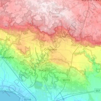
Name: Crispiano topographic map, elevation, terrain.

Location: Crispiano, Taranto, Apulia, 74012, Italy (40.55051 17.15003 40.65405 17.41834)

Average elevation: 243 m

Minimum elevation: -2 m

Maximum elevation: 522 m

Other topographic maps

Click on a map to view its topography, its elevation and its terrain.

Marinara

Italy > Apulia > Taranto > Mottola

Average elevation: 261 m

Saturo

Italy > Apulia > Taranto > Leporano

Average elevation: 12 m

Gear up for your next adventure:

🚲Bike Repair Kit - Essential tools for on-trail mechanical issues
Lightweight Backpacking Tent - Compact tent for efficient hiking trips
🔭Outdoor Binoculars - Lightweight binoculars for birdwatching and hiking
🌬️Windproof Camp Stove - Efficient cooking even on exposed mountain peaks
🔦UV Flashlight - Detect minerals or specific insects in the dark

As an Amazon Associate, this site earns from qualifying purchases at no extra cost to you.