Geolocate

Overberg topographic map

Click on the map to display elevation.

About this map
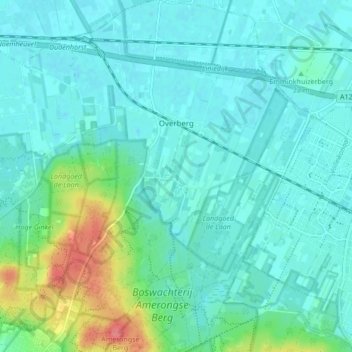
Name: Overberg topographic map, elevation, terrain.

Location: Overberg, Utrechtse Heuvelrug, Utrecht, Netherlands (52.00503 5.47650 52.05732 5.52938)

Average elevation: 17 m

Minimum elevation: 3 m

Maximum elevation: 72 m

Other topographic maps

Click on a map to view its topography, its elevation and its terrain.
Amersfoortse Berg

Netherlands > Utrecht > Amersfoort

Average elevation: 19 m

Breedeveen

Netherlands > Utrecht > Leersum

Average elevation: 15 m

Cabauw

Netherlands > Utrecht

Average elevation: -1 m

Amerongse Berg

Netherlands > Utrecht > Amerongen

Average elevation: 34 m

Eembrugge

Netherlands > Utrecht > Baarn

Average elevation: 1 m

Palestina

Netherlands > Utrecht > Amersfoort

Average elevation: 2 m

Gear up for your next adventure:

⛺Camping Groundsheet - Protect your tent from moisture and dirt
🧢Sun Hat - Wide-brim hat for sun protection
🧤Insulated Winter Gloves - Heavy-duty protection for sub-zero Canadian adventures
🪑Insulated Seat Pad - Protect your seat from cold rocks and wet logs
❄️Traction Ice Cleats - Slip-on spikes for icy trails and winter hiking

As an Amazon Associate, this site earns from qualifying purchases at no extra cost to you.