Geolocate

Chapel Hill topographic map

Click on the map to display elevation.

About this map
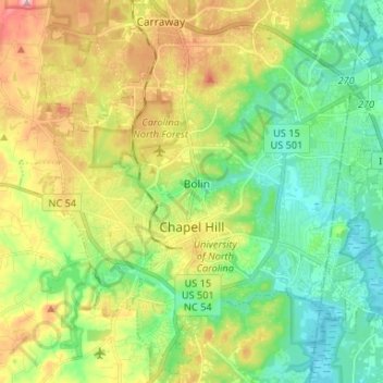
Name: Chapel Hill topographic map, elevation, terrain.

Location: Chapel Hill, Orange County, North Carolina, United States (35.86941 -79.08314 35.97614 -78.99539)

Average elevation: 126 m

Minimum elevation: 68 m

Maximum elevation: 225 m

Other topographic maps

Click on a map to view its topography, its elevation and its terrain.

Efland

United States > North Carolina > Orange County

Average elevation: 193 m

Efland

United States > North Carolina > Orange County

Average elevation: 193 m

Carr

United States > North Carolina > Orange County

Average elevation: 214 m

Berryland

United States > North Carolina > Orange County

Average elevation: 187 m

Gear up for your next adventure:

🔪Outdoor Multitool - Versatile tool for repairs and food prep in the wild
🥾Approach Boots - Comfortable boots for hiking and climbing approaches
🗺️Topographic Maps - Detailed maps to explore trails, mountains, and wilderness areas
🚑Survival Whistle - Signal for help across long distances in mountains
🍽️Titanium Camping Spork - Ultralight and indestructible eating utensil

As an Amazon Associate, this site earns from qualifying purchases at no extra cost to you.