
Make a donation
Gear up for your next adventure:
As an Amazon Associate, this site earns from qualifying purchases at no extra cost to you.
Efland topographic map
Click on the map to display elevation.
Make a donation
Gear up for your next adventure:
As an Amazon Associate, this site earns from qualifying purchases at no extra cost to you.
About this map
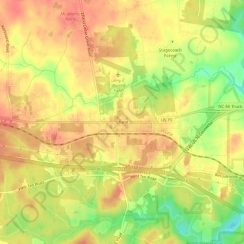
Name: Efland topographic map, elevation, terrain.
Location: Efland, Orange County, North Carolina, 27243, United States (36.06125 -79.18918 36.10125 -79.14918)
Average elevation: 193 m
Minimum elevation: 157 m
Maximum elevation: 212 m
Make a donation
Gear up for your next adventure:
As an Amazon Associate, this site earns from qualifying purchases at no extra cost to you.
Other topographic maps
Click on a map to view its topography, its elevation and its terrain.
Eno River State Park
United States > North Carolina > Orange County
The Cox Mountain Trail is marked by blue blazes. The 3.75-mile (6.04 km) trail passes a picnic area and crosses the suspension foot bridge. The trail goes up 270 feet (82 m) in elevation and at one point follows Hillsborough Coach Road. When getting closer to Cox Mountain, the trail can get fairly steep. The…
Average elevation: 167 m