
Oklahoma County topographic map
Click on the map to display elevation.
About this map
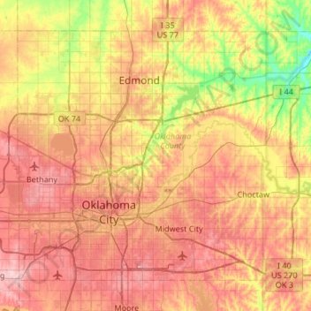
Name: Oklahoma County topographic map, elevation, terrain.
Location: Oklahoma County, Oklahoma, United States (35.37688 -97.67402 35.72598 -97.14104)
Average elevation: 354 m
Minimum elevation: 269 m
Maximum elevation: 432 m
Other topographic maps
Click on a map to view its topography, its elevation and its terrain.
Southwest Oklahoma City Sludge Lagoon Dam
United States > Oklahoma > Cleveland County > Oklahoma City
Average elevation: 348 m
Lake Thunderbird Dam
United States > Oklahoma > Cleveland County > Norman > Little Axe
Average elevation: 318 m