
Make a donation
Gear up for your next adventure:
As an Amazon Associate, this site earns from qualifying purchases at no extra cost to you.
Torija topographic map
Click on the map to display elevation.
Make a donation
Gear up for your next adventure:
As an Amazon Associate, this site earns from qualifying purchases at no extra cost to you.
Torija
Torija liegt im Südteil der Iberischen Meseta auf einer Höhe von etwa 960 m am Ende eines fruchtbaren Tales im gebirgigen Westen der Provinz Guadalajara. Die Provinzhauptstadt Guadalajara ist etwa 20 km (Fahrtstrecke) in südwestlicher Richtung entfernt; die spanische Hauptstadt Madrid befindet sich knapp 80 km in südwestlicher Richtung. Das Klima im Winter ist gemäßigt, im Sommer dagegen warm bis heiß; die eher geringen Niederschlagsmengen (ca. 415 mm/Jahr) fallen – mit Ausnahme der nahezu regenlosen Sommermonate – verteilt übers ganze Jahr.
Make a donation
Gear up for your next adventure:
As an Amazon Associate, this site earns from qualifying purchases at no extra cost to you.
About this map
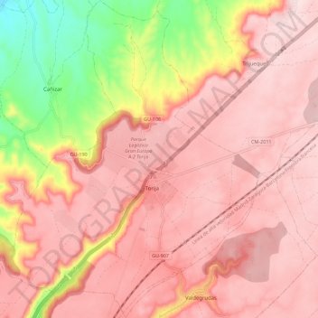
Name: Torija topographic map, elevation, terrain.
Location: Torija, Guadalajara, Kastilien-La Mancha, 19190, Spanien (40.70832 -3.08276 40.79346 -2.99416)
Average elevation: 920 m
Minimum elevation: 716 m
Maximum elevation: 1,008 m
Make a donation
Gear up for your next adventure:
As an Amazon Associate, this site earns from qualifying purchases at no extra cost to you.
Other topographic maps
Click on a map to view its topography, its elevation and its terrain.
Make a donation
Gear up for your next adventure:
As an Amazon Associate, this site earns from qualifying purchases at no extra cost to you.
Make a donation
Gear up for your next adventure:
As an Amazon Associate, this site earns from qualifying purchases at no extra cost to you.