Geolocate

Roquete topographic map

Click on the map to display elevation.

About this map

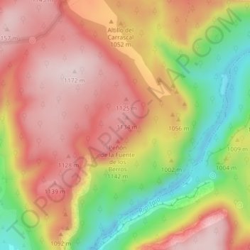
Name: Roquete topographic map, elevation, terrain.

Location: Roquete, Ocentejo, Guadalajara, Kastilien-La Mancha, Spanien (40.76884 -2.38631 40.78884 -2.36631)

Average elevation: 1,017 m

Minimum elevation: 805 m

Maximum elevation: 1,169 m

Gear up for your next adventure:

🧼Travel Hand Sanitizer - Keep hands clean when water is scarce
🧥Waterproof Jacket - Lightweight rain jackets for hiking and outdoor activities
🕶️Polarized Sunglasses - Reduces glare from snow and water at high elevations
🧦Outdoor Socks - Durable socks designed for hiking and outdoor sports
💡Portable Camping Lamp - Rechargeable lamp for campsite lighting

As an Amazon Associate, this site earns from qualifying purchases at no extra cost to you.