Geolocate

Grashevo topographic map

Click on the map to display elevation.

About this map

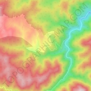
Name: Grashevo topographic map, elevation, terrain.

Location: Grashevo, Velingrad, Pazardzhik, Bulgaria (41.93765 23.90435 41.97765 23.94435)

Average elevation: 1,135 m

Minimum elevation: 861 m

Maximum elevation: 1,342 m

Gear up for your next adventure:

🥾Hiking Shorts - Breathable shorts suitable for summer hikes
🧰Multitool Knife - Compact and versatile tool for outdoor use
🥾Approach Shoes - Shoes designed for climbing approaches and rugged trails
🧼Biodegradable Camp Soap - Environmentally friendly cleaning for gear and body
🧢Hiking Hat - Sun-protective and breathable hats for long treks

As an Amazon Associate, this site earns from qualifying purchases at no extra cost to you.