
Make a donation
Gear up for your next adventure:
As an Amazon Associate, this site earns from qualifying purchases at no extra cost to you.
Akfadou topographic map
Click on the map to display elevation.
Make a donation
Gear up for your next adventure:
As an Amazon Associate, this site earns from qualifying purchases at no extra cost to you.
Akfadou
La région est dominée par deux sommets, l'un à l'ouest surplombant le plateau d'Akfadou où est implantée la station de la TDA (ex-RTA) atteint 1 623 m, l'autre à l'est Azrou Taghat culmine à 1 542 m d'altitude. La neige y est abondante en saison froide et les pluies dépassent 2 000 mm par an.
Make a donation
Gear up for your next adventure:
As an Amazon Associate, this site earns from qualifying purchases at no extra cost to you.
About this map
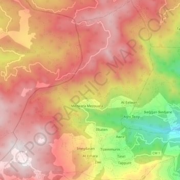
Name: Akfadou topographic map, elevation, terrain.
Location: Akfadou, Daïra Chemini, Béjaïa, 06411, Algérie (36.61843 4.56480 36.69691 4.65250)
Average elevation: 1,122 m
Minimum elevation: 366 m
Maximum elevation: 1,616 m
Make a donation
Gear up for your next adventure:
As an Amazon Associate, this site earns from qualifying purchases at no extra cost to you.
Other topographic maps
Click on a map to view its topography, its elevation and its terrain.
Make a donation
Gear up for your next adventure:
As an Amazon Associate, this site earns from qualifying purchases at no extra cost to you.