
Make a donation
Gear up for your next adventure:
As an Amazon Associate, this site earns from qualifying purchases at no extra cost to you.
Rutino topographic map
Click on the map to display elevation.
Make a donation
Gear up for your next adventure:
As an Amazon Associate, this site earns from qualifying purchases at no extra cost to you.
Rutino
Lustra<?> liegt auf etwa 370 Meter Höhe, nordöstlich des Monte Stella, des höchsten Bergs in der näheren Umgebung, und ist Teil des Nationalparks Cilento und Vallo di Diano, sowie der Comunità Montana Alento-Monte Stella.
Make a donation
Gear up for your next adventure:
As an Amazon Associate, this site earns from qualifying purchases at no extra cost to you.
About this map
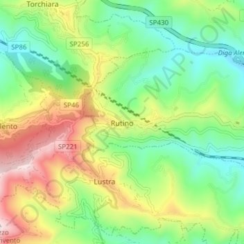
Name: Rutino topographic map, elevation, terrain.
Location: Rutino, Salerno, Kampanien, Italien (40.28554 15.06259 40.31431 15.12504)
Average elevation: 306 m
Minimum elevation: 85 m
Maximum elevation: 676 m
Make a donation
Gear up for your next adventure:
As an Amazon Associate, this site earns from qualifying purchases at no extra cost to you.
Other topographic maps
Click on a map to view its topography, its elevation and its terrain.
Make a donation
Gear up for your next adventure:
As an Amazon Associate, this site earns from qualifying purchases at no extra cost to you.