Geolocate

Minatitlán topographic map

Click on the map to display elevation.

About this map

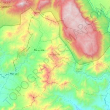
Name: Minatitlán topographic map, elevation, terrain.

Location: Minatitlán, Colima, Mexico (19.24577 -104.22743 19.49770 -103.88112)

Average elevation: 1,150 m

Minimum elevation: 298 m

Maximum elevation: 2,611 m

Other topographic maps

Click on a map to view its topography, its elevation and its terrain.

Manzanillo

Mexico > Colima > Manzanillo

Average elevation: 114 m

Villa de Álvarez

Mexico > Colima > Villa de Álvarez

Average elevation: 709 m

Alzada

Mexico > Colima > Cuauhtémoc

Average elevation: 630 m

Manzanillo

Mexico > Colima > Manzanillo

Average elevation: 114 m

La Caja

Mexico > Colima > Comala

Average elevation: 649 m

Tecoman

Mexico > Colima > Tecomán

Average elevation: 129 m

Colima City

Mexico > Colima > Municipio de Colima

Most of the municipality is located in the Valley of Colima. About half of the municipality has rugged, mountainous terrain, most of which is on the south and southeastern sides but with an average altitude of only 550 masl. These areas are part of the areas belonging to the Colima Volcano and a set of…

Average elevation: 649 m

Gear up for your next adventure:

🥾Waterproof Hiking Shoes - Durable shoes for wet and rugged trails
🛶Canoe Life Vest - Safety vest for water sports
Camping Groundsheet - Protect your tent from moisture and dirt
🧥Thermal Layer - Insulating layer for cold outdoor conditions
🥾Trekking Poles - Adjustable trekking poles to reduce knee stress and improve stability

As an Amazon Associate, this site earns from qualifying purchases at no extra cost to you.