Geolocate

Lorica topographic map

Click on the map to display elevation.

About this map

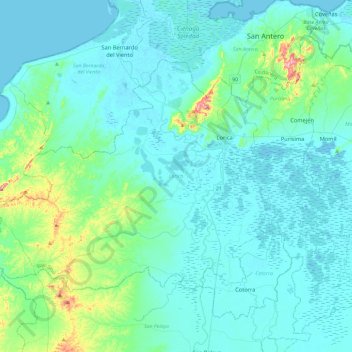
Name: Lorica topographic map, elevation, terrain.

Location: Lorica, Bajo Sínú, Córdoba, RAP Caribe, 231020, Colombia (9.03650 -76.15523 9.34165 -75.68745)

Average elevation: 28 m

Minimum elevation: -1 m

Maximum elevation: 228 m

Other topographic maps

Click on a map to view its topography, its elevation and its terrain.

Tierra Santa

Colombia > Córdoba > Buenavista

Average elevation: 31 m

La Ye

Colombia > Córdoba > Sahagún

Average elevation: 122 m

Gear up for your next adventure:

🎒Backpack Rain Cover - External shield to keep your entire pack dry
🔋Lithium AA Batteries - Long-lasting power that performs in extreme cold
Bushcraft Tarp - Versatile emergency shelter or gear protection
🧦Hiking Liner Socks - Thin base layer to prevent friction and blisters
🧴First Aid Kit - Essential first aid supplies for outdoor emergencies

As an Amazon Associate, this site earns from qualifying purchases at no extra cost to you.