Geolocate

King Island topographic map

Click on the map to display elevation.

About this map

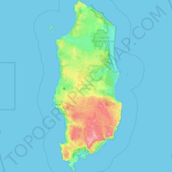
Name: King Island topographic map, elevation, terrain.

Location: King Island, Tasmania, 7256, Australia (-40.15799 143.83215 -39.57926 144.13822)

Average elevation: 14 m

Minimum elevation: 0 m

Maximum elevation: 159 m

Other topographic maps

Click on a map to view its topography, its elevation and its terrain.

Cathedral Mountain

Australia > Tasmania

Average elevation: 992 m

Waterworks Reserve

Australia > Tasmania > Hobart

Average elevation: 240 m

Rowlands Hill

Australia > Tasmania

Average elevation: 388 m

Cradle Mountain

Australia > Tasmania > Cradle Mountain

Average elevation: 1,144 m

The Nut

Australia > Tasmania > Stanley

Average elevation: 8 m

Bream Creek

Australia > Tasmania > Bream Creek

Average elevation: 35 m

West Gawler River

Australia > Tasmania > Sprent > Gawler

Average elevation: 201 m

Buxton Point

Australia > Tasmania > Little Swanport

Average elevation: 3 m

Mount Patrick

Australia > Tasmania

Average elevation: 863 m

Mount Ossa

Australia > Tasmania

Average elevation: 1,218 m

Mount Tyndall

Australia > Tasmania

Average elevation: 910 m

Gear up for your next adventure:

🦌Outdoor Trail Camera - Monitor wildlife activity near your favorite spots
🧥Waterproof Jacket - Lightweight rain jackets for hiking and outdoor activities
🕯️Camping Lantern - Illuminates your entire campsite with high-efficiency LEDs
🔥Camping Stove - Portable stoves to cook outdoors with ease
🧊Insulated Water Bottle - Keeps drinks cold in summer and prevents freezing in winter

As an Amazon Associate, this site earns from qualifying purchases at no extra cost to you.