Geolocate

The Nut topographic map

Click on the map to display elevation.

About this map

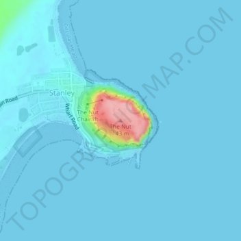
Name: The Nut topographic map, elevation, terrain.

Location: The Nut, Stanley, Circular Head, Tasmania, 7331, Australia (-40.76375 145.30314 -40.76365 145.30324)

Average elevation: 8 m

Minimum elevation: 0 m

Maximum elevation: 146 m

Gear up for your next adventure:

💡Compact LED Flashlight - Powerful and portable flashlight for outdoor use
🧰Survival Kit - Essential gear for emergencies in the wilderness
🧴Waterproofing Spray - Restore the DWR coating on jackets and tents
🧣Evaporative Cooling Towel - Beat the heat during intense summer climbs
🧦Crew Hiking Socks - Comfortable socks for long-distance hikes

As an Amazon Associate, this site earns from qualifying purchases at no extra cost to you.