Geolocate

Sapang II topographic map

Click on the map to display elevation.

About this map

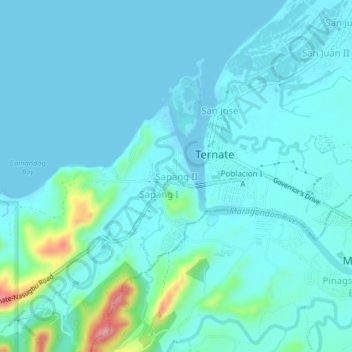
Name: Sapang II topographic map, elevation, terrain.

Location: Sapang II, Ternate, Cavite, Calabarzon, 4111, Philippines (14.26367 120.69153 14.30367 120.73153)

Average elevation: 18 m

Minimum elevation: -3 m

Maximum elevation: 134 m

Other topographic maps

Click on a map to view its topography, its elevation and its terrain.

Pico de Loro

Philippines > Cavite > Ternate

Average elevation: 382 m

Marine Base Beach

Philippines > Cavite > Ternate

Average elevation: 35 m

Sapang I

Philippines > Cavite > Ternate

Average elevation: 104 m

Paniman Beach

Philippines > Cavite > Ternate > Sapang I

Average elevation: 29 m

Gear up for your next adventure:

Family Camping Tent - Spacious tent suitable for family camping trips
🥾Light Trekking Boots - Supportive boots for multi-day treks
🧥Waterproof Jacket - Lightweight rain jackets for hiking and outdoor activities
💧Hydration Pack - Hands-free hydration system for long hikes
🛁Quick-Dry Microfiber Towel - Space-saving towel that dries rapidly on the move

As an Amazon Associate, this site earns from qualifying purchases at no extra cost to you.