Geolocate

Pico de Loro topographic map

Click on the map to display elevation.

About this map

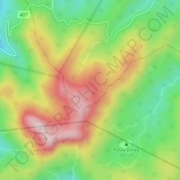
Name: Pico de Loro topographic map, elevation, terrain.

Location: Pico de Loro, Ternate, Cavite, Calabarzon, 4111, Philippines (14.21073 120.63499 14.23598 120.66697)

Average elevation: 382 m

Minimum elevation: 173 m

Maximum elevation: 631 m

Other topographic maps

Click on a map to view its topography, its elevation and its terrain.

Bucana

Philippines > Cavite > Ternate

Average elevation: 21 m

Sapang II

Philippines > Cavite > Ternate

Average elevation: 18 m

Sapang I

Philippines > Cavite > Ternate

Average elevation: 104 m

Bucana

Philippines > Cavite > Ternate

Average elevation: 21 m

Gear up for your next adventure:

📷Outdoor Action Camera - Capture high-elevation views and rugged adventures
🪑Insulated Seat Pad - Protect your seat from cold rocks and wet logs
🥤Collapsible Travel Cup - Saves space and weight in your mess kit
🛁Quick-Dry Microfiber Towel - Space-saving towel that dries rapidly on the move
🧴Waterproofing Spray - Restore the DWR coating on jackets and tents

As an Amazon Associate, this site earns from qualifying purchases at no extra cost to you.