
Restoule Lake topographic map
Interactive map
Click on the map to display elevation.
About this map
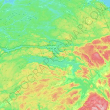
Name: Restoule Lake topographic map, elevation, terrain.
Average elevation: 244 m
Minimum elevation: 191 m
Maximum elevation: 350 m
Parry Sound District trails, hiking, mountain biking, running and outdoor activities
Other topographic maps
Click on a map to view its topography, its elevation and its terrain.
Stormy Lake
Canada > Ontario > Parry Sound District > Unorganized Centre Parry Sound
Average elevation: 227 m
Arnstein
Canada > Ontario > Parry Sound District > Unorganized Centre Parry Sound
Average elevation: 233 m
Memesagamesing Lake Dam
Canada > Ontario > Parry Sound District > Unorganized Centre Parry Sound
Average elevation: 227 m
Dollars Lake
Canada > Ontario > Parry Sound District > Unorganized Centre Parry Sound
Average elevation: 215 m
Bob's Lake
Canada > Ontario > Parry Sound District > Unorganized Centre Parry Sound
Average elevation: 255 m
Culin Lake
Canada > Ontario > Parry Sound District > Unorganized Centre Parry Sound > Arnstein
Average elevation: 230 m
Port Loring
Canada > Ontario > Parry Sound District > Unorganized Centre Parry Sound
Average elevation: 227 m
Pickerel River
Canada > Ontario > Parry Sound District > Unorganized Centre Parry Sound
Average elevation: 200 m
Dokis Island
Canada > Ontario > Parry Sound District > Unorganized Centre Parry Sound
Average elevation: 196 m
Key River
Canada > Ontario > Parry Sound District > Unorganized Centre Parry Sound
Average elevation: 194 m
Cole Lake
Canada > Ontario > Parry Sound District > Unorganized Centre Parry Sound
Average elevation: 216 m
Bosworth Island
Canada > Ontario > Parry Sound District > Unorganized Centre Parry Sound
Average elevation: 224 m
Restoule
Canada > Ontario > Parry Sound District > Unorganized Centre Parry Sound
Average elevation: 237 m
Magnetawan River
Canada > Ontario > Parry Sound District > Unorganized Centre Parry Sound
Average elevation: 198 m
Clear Lake
Canada > Ontario > Parry Sound District > Unorganized Centre Parry Sound
Average elevation: 222 m
Key Harbour
Canada > Ontario > Parry Sound District > Unorganized Centre Parry Sound
Average elevation: 178 m
Britt
Canada > Ontario > Parry Sound District > Unorganized Centre Parry Sound
Average elevation: 186 m
Loring
Canada > Ontario > Parry Sound District > Unorganized Centre Parry Sound
Average elevation: 241 m
Key River
Canada > Ontario > Parry Sound District > Unorganized Centre Parry Sound
Average elevation: 193 m
Smith Bay
Canada > Ontario > Parry Sound District > Unorganized Centre Parry Sound
Average elevation: 217 m
Recollet Falls
Canada > Ontario > Parry Sound District > Unorganized Centre Parry Sound
Average elevation: 206 m