
Britt topographic map
Interactive map
Click on the map to display elevation.
About this map
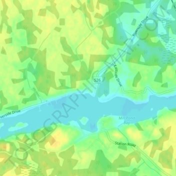
Name: Britt topographic map, elevation, terrain.
Average elevation: 186 m
Minimum elevation: 174 m
Maximum elevation: 197 m
Other topographic maps
Click on a map to view its topography, its elevation and its terrain.
Dollars Lake
Canada > Ontario > Parry Sound District > Unorganized Centre Parry Sound
Dollars Lake, Unorganized Centre Parry Sound, Parry Sound District, Central Ontario, Ontario, Canada
Average elevation: 215 m
Bob's Lake
Canada > Ontario > Parry Sound District > Unorganized Centre Parry Sound
Bob's Lake, Unorganized Centre Parry Sound, Parry Sound District, Central Ontario, Ontario, Canada
Average elevation: 255 m
Culin Lake
Canada > Ontario > Parry Sound District > Unorganized Centre Parry Sound > Arnstein
Culin Lake, Arnstein, Unorganized Centre Parry Sound, Parry Sound District, Central Ontario, Ontario, Canada
Average elevation: 230 m
Pickerel River
Canada > Ontario > Parry Sound District > Unorganized Centre Parry Sound
Pickerel River, Unorganized Centre Parry Sound, Parry Sound District, Central Ontario, Ontario, Canada
Average elevation: 200 m
Dokis Island
Canada > Ontario > Parry Sound District > Unorganized Centre Parry Sound
Dokis Island, Unorganized Centre Parry Sound, Parry Sound District, Central Ontario, Ontario, Canada
Average elevation: 196 m
Port Loring
Canada > Ontario > Parry Sound District > Unorganized Centre Parry Sound
Port Loring, Unorganized Centre Parry Sound, Parry Sound District, Central Ontario, Ontario, P0H 1S0, Canada
Average elevation: 227 m
Grundy Lake Provincial Park
Canada > Ontario > Parry Sound District > Unorganized Centre Parry Sound
Grundy Lake Provincial Park, Unorganized Centre Parry Sound, Parry Sound District, Central Ontario, Ontario, Canada
Average elevation: 197 m
Key River
Canada > Ontario > Parry Sound District > Unorganized Centre Parry Sound
Key River, Unorganized Centre Parry Sound, Parry Sound District, Central Ontario, Ontario, Canada
Average elevation: 194 m
Bosworth Island
Canada > Ontario > Parry Sound District > Unorganized Centre Parry Sound
Bosworth Island, Unorganized Centre Parry Sound, Parry Sound District, Central Ontario, Ontario, Canada
Average elevation: 224 m
Cole Lake
Canada > Ontario > Parry Sound District > Unorganized Centre Parry Sound
Cole Lake, Unorganized Centre Parry Sound, Parry Sound District, Central Ontario, Ontario, Canada
Average elevation: 216 m
Restoule
Canada > Ontario > Parry Sound District > Unorganized Centre Parry Sound
Restoule, Unorganized Centre Parry Sound, Parry Sound District, Central Ontario, Ontario, P0H 2R0, Canada
Average elevation: 237 m
Magnetawan River
Canada > Ontario > Parry Sound District > Unorganized Centre Parry Sound
Magnetawan River, Unorganized Centre Parry Sound, Parry Sound District, Central Ontario, Ontario, Canada
Average elevation: 198 m
Clear Lake
Canada > Ontario > Parry Sound District > Unorganized Centre Parry Sound
Clear Lake, Unorganized Centre Parry Sound, Parry Sound District, Central Ontario, Ontario, Canada
Average elevation: 222 m
Key Harbour
Canada > Ontario > Parry Sound District > Unorganized Centre Parry Sound
Key Harbour, Unorganized Centre Parry Sound, Parry Sound District, Central Ontario, Ontario, Canada
Average elevation: 178 m
Loring
Canada > Ontario > Parry Sound District > Unorganized Centre Parry Sound
Loring, Unorganized Centre Parry Sound, Parry Sound District, Central Ontario, Ontario, P0H 1Y0, Canada
Average elevation: 241 m
Restoule Lake
Canada > Ontario > Parry Sound District > Unorganized Centre Parry Sound
Restoule Lake, Unorganized Centre Parry Sound, Parry Sound District, Central Ontario, Ontario, Canada
Average elevation: 244 m
Recollet Falls
Canada > Ontario > Parry Sound District > Unorganized Centre Parry Sound
Recollet Falls, Unorganized Centre Parry Sound, Parry Sound District, Central Ontario, Ontario, Canada
Average elevation: 206 m
Smith Bay
Canada > Ontario > Parry Sound District > Unorganized Centre Parry Sound
Smith Bay, Unorganized Centre Parry Sound, Parry Sound District, Central Ontario, Ontario, Canada
Average elevation: 217 m
Key River
Canada > Ontario > Parry Sound District > Unorganized Centre Parry Sound
Key River, Unorganized Centre Parry Sound, Parry Sound District, Central Ontario, Ontario, Canada
Average elevation: 193 m
Pakesley
Canada > Ontario > Parry Sound District > Unorganized Centre Parry Sound
Pakesley, Unorganized Centre Parry Sound, Parry Sound District, Central Ontario, Ontario, Canada
Average elevation: 199 m