
Make a donation
Gear up for your next adventure:
As an Amazon Associate, this site earns from qualifying purchases at no extra cost to you.
Almendra topographic map
Click on the map to display elevation.
Make a donation
Gear up for your next adventure:
As an Amazon Associate, this site earns from qualifying purchases at no extra cost to you.
About this map
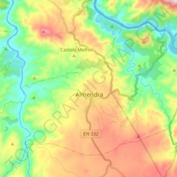
Name: Almendra topographic map, elevation, terrain.
Location: Almendra, Vila Nova de Foz Côa, Guarda, 5150-072, Portugal (40.96713 -7.10717 41.04137 -6.97667)
Average elevation: 366 m
Minimum elevation: 125 m
Maximum elevation: 743 m
Make a donation
Gear up for your next adventure:
As an Amazon Associate, this site earns from qualifying purchases at no extra cost to you.
Other topographic maps
Click on a map to view its topography, its elevation and its terrain.
Miradouro de Horta do Douro
Portugal > Guarda > Vila Nova de Foz Coa > Horta > Senhora da Estrada
Average elevation: 563 m
Make a donation
Gear up for your next adventure:
As an Amazon Associate, this site earns from qualifying purchases at no extra cost to you.