Geolocate

Storvik topographic map

Click on the map to display elevation.

About this map

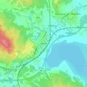
Name: Storvik topographic map, elevation, terrain.

Location: Storvik, Sandvikens kommun, Gävleborg County, 812 30, Sweden (60.56534 16.51503 60.60534 16.55503)

Average elevation: 78 m

Minimum elevation: 57 m

Maximum elevation: 141 m

Other topographic maps

Click on a map to view its topography, its elevation and its terrain.

Gävle

Sweden > Gävleborg County

Average elevation: 28 m

Gran

Sweden > Gävleborg County > Gnarp District

Average elevation: 0 m

Ljusdals kommun

Sweden > Gävleborg County

Average elevation: 315 m

Disan

Sweden > Gävleborg County

Average elevation: 43 m

Hamra

Sweden > Gävleborg County

Average elevation: 437 m

Hamra

Sweden > Gävleborg County

Average elevation: 437 m

Hudiksvalls kommun

Sweden > Gävleborg County

Average elevation: 95 m

Hamra

Sweden > Gävleborg County

Average elevation: 437 m

Söderhamns kommun

Sweden > Gävleborg County

Average elevation: 67 m

Gnarp District

Sweden > Gävleborg County

Average elevation: 32 m

Gävle kommun

Sweden > Gävleborg County

Average elevation: 61 m

Ovanåkers kommun

Sweden > Gävleborg County

Average elevation: 269 m

Hofors kommun

Sweden > Gävleborg County

Average elevation: 147 m

Gear up for your next adventure:

🥾Mountain Trail Shoes - High-traction shoes for mountain trails
🧥Ultralight Puffy Jacket - Maximum warmth that packs down to the size of an orange
🔪Outdoor Multitool - Versatile tool for repairs and food prep in the wild
🧴Bear Spray Holster - Quick-access carry for essential Canadian wilderness safety
🎒Hiking Backpack - Lightweight and ergonomic backpacks for day hikes or multi-day treks

As an Amazon Associate, this site earns from qualifying purchases at no extra cost to you.