
Mackworth topographic map
Click on the map to display elevation.
About this map
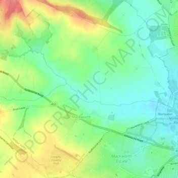
Name: Mackworth topographic map, elevation, terrain.
Location: Mackworth, Amber Valley, Derbyshire, England, United Kingdom (52.92419 -1.55995 52.95687 -1.50661)
Average elevation: 87 m
Minimum elevation: 57 m
Maximum elevation: 136 m
Other topographic maps
Click on a map to view its topography, its elevation and its terrain.
Farnah Green
United Kingdom > England > Derbyshire > Amber Valley > Blackbrook > Farnah Green
Average elevation: 117 m
Moscow Farm
United Kingdom > England > Derbyshire > Amber Valley > Makeney > Moscow Farm
Average elevation: 103 m
Upper Holloway
United Kingdom > England > Derbyshire > Amber Valley > Holloway
Average elevation: 189 m
Heanor
United Kingdom > England > Derbyshire > Amber Valley
Samuel Lewis's A Topographical Dictionary of England, published in 1848, states that Heanor parish "abounds with coal and ironstone, both worked extensively, the collieries alone affording employment to more than 2000 persons. The town is pleasantly situated upon an eminence, on the road from Derby to…
Average elevation: 102 m
Denby Bottles
United Kingdom > England > Derbyshire > Amber Valley > Denby CP
Average elevation: 108 m
Rawson Green
United Kingdom > England > Derbyshire > Amber Valley > Kilburn CP
Average elevation: 109 m
Nottingham Canal
United Kingdom > England > Derbyshire > Amber Valley > Langley Mill
Average elevation: 77 m
Alfreton Park
United Kingdom > England > Derbyshire > Amber Valley > Alfreton CP > Oakerthorpe
Average elevation: 116 m
Plaistow Green
United Kingdom > England > Derbyshire > Amber Valley > Crich CP
Average elevation: 180 m
Upper Hartshay
United Kingdom > England > Derbyshire > Amber Valley > Upper Hartshay
Average elevation: 119 m
Sawmills
United Kingdom > England > Derbyshire > Amber Valley > Ripley > Fritchley
Average elevation: 119 m
Heanor
United Kingdom > England > Derbyshire > Amber Valley
Samuel Lewis's A Topographical Dictionary of England, published in 1848, states that Heanor parish "abounds with coal and ironstone, both worked extensively, the collieries alone affording employment to more than 2000 persons. The town is pleasantly situated upon an eminence, on the road from Derby to…
Average elevation: 102 m