Geolocate

Mattannur topographic map

Click on the map to display elevation.

About this map

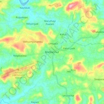
Name: Mattannur topographic map, elevation, terrain.

Location: Mattannur, Thalassery, Kannur, Kerala, 670702, India (11.89076 75.53126 11.97076 75.61126)

Average elevation: 59 m

Minimum elevation: 2 m

Maximum elevation: 183 m

Other topographic maps

Click on a map to view its topography, its elevation and its terrain.

Eranholi

India > Kerala > Thalassery > Thalassery

Average elevation: 16 m

Manatheri

India > Kerala > Thalassery > Kaitheri > Manantheri

Average elevation: 63 m

Kotheri

India > Kerala > Thalassery > Nagavalavu

Average elevation: 77 m

Pattiam

India > Kerala > Thalassery > Cheruvanchery

Average elevation: 80 m

Kanakamala

India > Kerala > Thalassery > Mekkunnu > Mukkilpeedika

Average elevation: 21 m

Arayalthara

India > Kerala > Thalassery > Aniyaram

Average elevation: 19 m

Panoor

India > Kerala > Thalassery > Mekkunnu

Average elevation: 19 m

Mooryad Centre

India > Kerala > Thalassery > Koothuparamba

Average elevation: 63 m

Kuthuparamba

India > Kerala > Thalassery > Koothuparamba

Average elevation: 61 m

Kadirur

India > Kerala > Thalassery > Kadirur

Average elevation: 18 m

New Mahe

India > Kerala > Thalassery > Chokli

Average elevation: 17 m

Kallerikkara

India > Kerala > Thalassery > Mattannur

Average elevation: 53 m

Kannavam

India > Kerala > Thalassery

Average elevation: 73 m

Gear up for your next adventure:

🪑Insulated Seat Pad - Protect your seat from cold rocks and wet logs
🦶Anti-Blister Balm - Prevents friction and hotspots during long ascents
🥾Trail Running Shoes - Lightweight and durable shoes for trail running
🦯Trekking Poles - Reduced impact on joints for steep topographic climbs
🧴First Aid Kit - Essential first aid supplies for outdoor emergencies

As an Amazon Associate, this site earns from qualifying purchases at no extra cost to you.