Geolocate

Rind topographic map

Click on the map to display elevation.

About this map

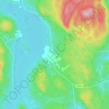
Name: Rind topographic map, elevation, terrain.

Location: Rind, Bräcke kommun, Jämtland County, Sweden (62.81601 15.18655 62.85601 15.22655)

Average elevation: 345 m

Minimum elevation: 285 m

Maximum elevation: 495 m

Other topographic maps

Click on a map to view its topography, its elevation and its terrain.

Storsjön

Sweden > Jämtland County

Average elevation: 404 m

Storulvån

Sweden > Jämtland County

Average elevation: 928 m

Edsåsen

Sweden > Jämtland County

Average elevation: 445 m

Härjedalens kommun

Sweden > Jämtland County

Average elevation: 563 m

Näkten

Sweden > Jämtland County

Average elevation: 374 m

Krokoms kommun

Sweden > Jämtland County

Average elevation: 501 m

Delsjön

Sweden > Jämtland County

Average elevation: 410 m

Krokoms kommun

Sweden > Jämtland County

Average elevation: 501 m

Finnån

Sweden > Jämtland County

Average elevation: 596 m

Strömsunds kommun

Sweden > Jämtland County

Average elevation: 475 m

Bergs kommun

Sweden > Jämtland County

Average elevation: 575 m

Östersunds kommun

Sweden > Jämtland County

Average elevation: 372 m

Ragunda kommun

Sweden > Jämtland County

Average elevation: 315 m

Rogen

Sweden > Jämtland County

Average elevation: 802 m

Sonfjället

Sweden > Jämtland County

Average elevation: 685 m

Lillhärdal

Sweden > Jämtland County

Average elevation: 459 m

Bräcke kommun

Sweden > Jämtland County

Average elevation: 340 m

Gear up for your next adventure:

🧣Evaporative Cooling Towel - Beat the heat during intense summer climbs
🧼Travel Hand Sanitizer - Keep hands clean when water is scarce
Tent Footprint - Protect tent floor and increase durability
🦌Outdoor Trail Camera - Monitor wildlife activity near your favorite spots
🚲Handlebar Phone Mount - View topographic-map.com live while cycling

As an Amazon Associate, this site earns from qualifying purchases at no extra cost to you.