Geolocate

Gestingthorpe topographic map

Click on the map to display elevation.

About this map

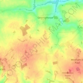
Name: Gestingthorpe topographic map, elevation, terrain.

Location: Gestingthorpe, Braintree, Essex, England, United Kingdom (51.98390 0.60716 52.02603 0.66932)

Average elevation: 69 m

Minimum elevation: 35 m

Maximum elevation: 94 m

Other topographic maps

Click on a map to view its topography, its elevation and its terrain.

Ashen

United Kingdom > England > Braintree > Ashen

Average elevation: 72 m

Doe's Corner

United Kingdom > England > Braintree > Doe's Corner

Average elevation: 24 m

Gear up for your next adventure:

🥾Waterproof Trail Shoes - Shoes designed to handle wet terrain
🪑Insulated Seat Pad - Protect your seat from cold rocks and wet logs
💡Portable Camping Lamp - Rechargeable lamp for campsite lighting
🧴Insect Repellent - Protect yourself from bugs during outdoor adventures
🧥Waterproof Hiking Jacket - Protect yourself from rain and wind while hiking

As an Amazon Associate, this site earns from qualifying purchases at no extra cost to you.